Dingy-Saint-Clair
| Dingy-Saint-Clair | |
|---|---|
|
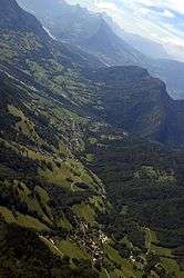
Dingy-Saint-Clair seen from the Parmelan | |
 Dingy-Saint-Clair | |
|
Location within Auvergne-Rhône-Alpes region  Dingy-Saint-Clair | |
| Coordinates: 45°54′45″N 6°13′23″E / 45.9125°N 6.2231°ECoordinates: 45°54′45″N 6°13′23″E / 45.9125°N 6.2231°E | |
| Country | France |
| Region | Auvergne-Rhône-Alpes |
| Department | Haute-Savoie |
| Arrondissement | Arrondissement of Annecy |
| Canton | Canton of Annecy-le-Vieux |
| Government | |
| • Mayor (2008–2014) | Monique Zurecki |
| Area1 | 34.12 km2 (13.17 sq mi) |
| Population (1999)2 | 915 |
| • Density | 27/km2 (69/sq mi) |
| Time zone | CET (UTC+1) |
| • Summer (DST) | CEST (UTC+2) |
| INSEE/Postal code | 74102 / 74230 |
| Elevation |
492–1,856 m (1,614–6,089 ft) (avg. 594 m or 1,949 ft) |
|
1 French Land Register data, which excludes lakes, ponds, glaciers > 1 km² (0.386 sq mi or 247 acres) and river estuaries. 2 Population without double counting: residents of multiple communes (e.g., students and military personnel) only counted once. | |
Dingy-Saint-Clair is a commune in the Haute-Savoie department in the Auvergne-Rhône-Alpes region in south-eastern France.
Geography
The commune is around 5 kilometres (3 mi) east of Annecy. The Fier forms the commune's south-western border.
See also
References
| Wikimedia Commons has media related to Dingy-Saint-Clair. |
This article is issued from Wikipedia - version of the 10/28/2016. The text is available under the Creative Commons Attribution/Share Alike but additional terms may apply for the media files.