Eagle Grove, Georgia
| Eagle Grove, Georgia | |
|---|---|
| Census-designated place | |
 Eagle Grove, Georgia | |
| Coordinates: 34°17′46″N 83°00′25″W / 34.29611°N 83.00694°WCoordinates: 34°17′46″N 83°00′25″W / 34.29611°N 83.00694°W | |
| Country | United States |
| State | Georgia |
| County | Hart |
| Area[1] | |
| • Total | 1.752 sq mi (4.54 km2) |
| • Land | 1.731 sq mi (4.48 km2) |
| • Water | 0.021 sq mi (0.05 km2) |
| Elevation | 823 ft (251 m) |
| Population (2010) | |
| • Total | 164 |
| • Density | 94/sq mi (36/km2) |
| Time zone | Eastern (EST) (UTC-5) |
| • Summer (DST) | EDT (UTC-4) |
| Area code(s) | 706 & 762 |
| GNIS feature ID | 326255[2] |
Eagle Grove is a census-designated place and unincorporated community in Hart County, Georgia, United States. Its population was 164 as of the 2010 census.[1] U.S. Route 29 passes through the community.
References
- 1 2 "2010 Census Gazetteer Files - Places: Georgia". U.S. Census Bureau. Retrieved January 4, 2015.
- ↑ "Eagle Grove". Geographic Names Information System. United States Geological Survey.
Municipalities and communities of Hart County, Georgia, United States | ||
|---|---|---|
| City | 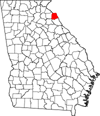 | |
| Town | ||
| CDPs | ||
| Footnotes | ‡This populated place also has portions in an adjacent county or counties | |
This article is issued from Wikipedia - version of the 1/4/2015. The text is available under the Creative Commons Attribution/Share Alike but additional terms may apply for the media files.