Edwards, Missouri
| Edwards, Missouri | |
|---|---|
| Unincorporated community | |
 Edwards, Missouri | |
| Coordinates: 38°08′12″N 93°10′11″W / 38.13667°N 93.16972°WCoordinates: 38°08′12″N 93°10′11″W / 38.13667°N 93.16972°W | |
| Country | United States |
| State | Missouri |
| County | Benton |
| Elevation | 791 ft (241 m) |
| Time zone | Central (CST) (UTC-6) |
| • Summer (DST) | CDT (UTC-5) |
| Area code(s) | 660 |
| GNIS feature ID | 717410[1] |
Edwards is an unincorporated community in southeastern Benton County, Missouri.[1] It is located on Route 7 about sixteen miles (26 km) southeast of Warsaw. It is a 16-minute drive from Climax Springs. Edwards has an elevation of 791 feet (241 m).
A post office was established at Edwards in 1883.[2] The community has the name of a local landowner.[3]
References
- 1 2 "Edwards". Geographic Names Information System. United States Geological Survey.
- ↑ "Post Offices". Jim Forte Postal History. Retrieved 1 September 2016.
- ↑ "Benton County Place Names, 1928–1945 (archived)". The State Historical Society of Missouri. Retrieved 2 September 2016.
Municipalities and communities of Benton County, Missouri, United States | ||
|---|---|---|
| Cities | 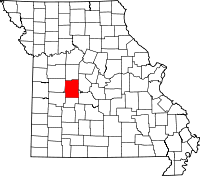 | |
| Village | ||
| Townships |
| |
| Unincorporated communities |
| |
| Former settlements | ||
| Footnotes | ‡This populated place also has portions in an adjacent county or counties | |
This article is issued from Wikipedia - version of the 9/3/2016. The text is available under the Creative Commons Attribution/Share Alike but additional terms may apply for the media files.