Endee, New Mexico
| Endee, New Mexico | |
|---|---|
| Unincorporated community | |
 Endee, New Mexico | |
| Coordinates: 35°08′16″N 103°06′28″W / 35.13778°N 103.10778°WCoordinates: 35°08′16″N 103°06′28″W / 35.13778°N 103.10778°W | |
| Country | United States |
| State | New Mexico |
| County | Quay |
| Elevation | 3,822 ft (1,165 m) |
| Time zone | Mountain (MST) (UTC-7) |
| • Summer (DST) | MDT (UTC-6) |
| GNIS feature ID | 898546[1] |
Endee is an unincorporated community on the route of historic Route 66 in Quay County, New Mexico.[1][2] The town was founded around 1885 named after the brand of the ND Ranch.[3] A post office operated in Endee from 1886 to 1955.[3] In 1952, Route 66 was rerouted so it bypassed Endee.[2]
References
- 1 2 "Montoya". Geographic Names Information System. United States Geological Survey.
- 1 2 Hinckley, Jim (2012). The Route 66 Encyclopedia. Voyageur Press. p. 98. ISBN 978-0760340417.
- 1 2 Julyan, Robert Hixson (1998). The Place Names of New Mexico (revised ed.). Albuquerque, New Mexico: University of New Mexico Press. p. 124.
Municipalities and communities of Quay County, New Mexico, United States | ||
|---|---|---|
| City | 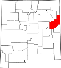 | |
| Villages | ||
| CDP | ||
| Other unincorporated communities | ||
| Footnotes | ‡This populated place also extends into Texas | |
This article is issued from Wikipedia - version of the 9/22/2016. The text is available under the Creative Commons Attribution/Share Alike but additional terms may apply for the media files.