Farlington, Kansas
| Farlington, Kansas | |
|---|---|
| Unincorporated community | |
 Farlington, Kansas  Farlington, Kansas | |
| Coordinates: 37°37′04″N 94°49′40″W / 37.61778°N 94.82778°WCoordinates: 37°37′04″N 94°49′40″W / 37.61778°N 94.82778°W | |
| Country | United States |
| State | Kansas |
| County | Crawford |
| Elevation | 991 ft (302 m) |
| Time zone | Central (CST) (UTC-6) |
| • Summer (DST) | CDT (UTC-5) |
| ZIP code | 66734 |
| Area code(s) | 620 |
| GNIS feature ID | 475139[1] |
Farlington is an unincorporated community in Crawford County, Kansas, United States. Farlington is located near K-7 8 miles (13 km) north of Girard. Farlington has a post office with ZIP code 66734.[2]
History
The first post office in Farlington was established in July, 1870.[3]
Farlington was a shipping point on the St. Louis–San Francisco Railway, and was laid out in 1869 when that line was extended to it.[4][5]
References
- ↑ "US Board on Geographic Names". United States Geological Survey. 2007-10-25. Retrieved 2008-01-31.
- ↑ ZIP Code Lookup
- ↑ "Kansas Post Offices, 1828-1961 (archived)". Kansas Historical Society. Archived from the original on October 9, 2013. Retrieved 6 June 2014.
- ↑ Blackmar, Frank Wilson (1912). Kansas: A Cyclopedia of State History, Embracing Events, Institutions, Industries, Counties, Cities, Towns, Prominent Persons, Etc. Standard Publishing Company. p. 621.
- ↑ A Twentieth Century History and Biographical Record of Crawford County, Kansas. The Lewis Publishing Company. 1905. p. 32.
Municipalities and communities of Crawford County, Kansas, United States | ||
|---|---|---|
| Cities | 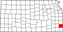 | |
| Townships | ||
| CDPs | ||
| Unincorporated communities | ||
| Footnotes | ‡This populated place also has portions in an adjacent county or counties | |
This article is issued from Wikipedia - version of the 10/24/2016. The text is available under the Creative Commons Attribution/Share Alike but additional terms may apply for the media files.