Fern Prairie, Washington
| Fern Prairie, Washington | |
|---|---|
| Census-designated place | |
 Fern Prairie Location of Fern Prairie, Washington | |
| Coordinates: 45°38′11″N 122°23′55″W / 45.63639°N 122.39861°WCoordinates: 45°38′11″N 122°23′55″W / 45.63639°N 122.39861°W | |
| Country | United States |
| State | Washington |
| County | Clark |
| Area | |
| • Total | 5.0 sq mi (13.0 km2) |
| • Land | 5.0 sq mi (13.0 km2) |
| • Water | 0.0 sq mi (0.0 km2) |
| Elevation | 459 ft (140 m) |
| Population (2010) | |
| • Total | 1,884 |
| • Density | 376/sq mi (145.0/km2) |
| Time zone | Pacific (PST) (UTC-8) |
| • Summer (DST) | PDT (UTC-7) |
| FIPS code | 53-23690 |
| GNIS feature ID | 1519499 |
Fern Prairie is a census-designated place (CDP) in Clark County, Washington, United States. The population was 1,884 at the 2010 census.[1]
It is located in southern Clark County, 16 miles (26 km) east of downtown Vancouver and 4 miles (6 km) north of Camas.
References
- ↑ "Geographic Identifiers: 2010 Demographic Profile Data (G001): Fern Prairie CDP, Washington". U.S. Census Bureau, American Factfinder. Retrieved August 31, 2015.
Municipalities and communities of Clark County, Washington, United States | ||
|---|---|---|
| Cities | 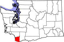 | |
| Town | ||
| CDPs | ||
| Other unincorporated communities | ||
| Footnotes | ‡This populated place also has portions in an adjacent county or counties | |
This article is issued from Wikipedia - version of the 8/31/2015. The text is available under the Creative Commons Attribution/Share Alike but additional terms may apply for the media files.