Fort Apache, Arizona
| Fort Apache, Arizona | |
|---|---|
| Unincorporated community | |
 Fort Apache, Arizona  Fort Apache, Arizona | |
| Coordinates: 33°47′26″N 109°59′12″W / 33.79056°N 109.98667°WCoordinates: 33°47′26″N 109°59′12″W / 33.79056°N 109.98667°W | |
| Country | United States |
| State | Arizona |
| County | Navajo |
| Elevation | 5,056 ft (1,541 m) |
| Time zone | Mountain (MST) (UTC-7) |
| ZIP code | 85926 |
| Area code(s) | 928 |
| GNIS feature ID | 4740[1] |
Fort Apache (Western Apache: Tłʼog Hagai) is an unincorporated community in Navajo County, Arizona, United States. Fort Apache is on the Fort Apache Indian Reservation 2 miles (3.2 km) east of Canyon Day. Fort Apache has a post office with ZIP code 85926.[2]
Climate
This region experiences warm (but not hot) and dry summers, with no average monthly temperatures above 71.6 °F (22.0 °C). According to the Köppen Climate Classification system, Fort Apache has a warm-summer Mediterranean climate, abbreviated "Csb" on climate maps.[3]
References
- ↑ "US Board on Geographic Names". United States Geological Survey. 2007-10-25. Retrieved 2008-01-31.
- ↑ ZIP Code Lookup
- ↑ Climate Summary for Fort Apache, Arizona
| Cities | 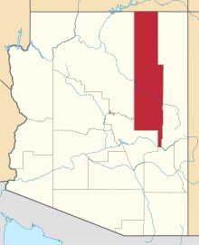 | |
|---|---|---|
| Towns | ||
| CDPs |
| |
| Unincorporated communities | ||
| Indian reservations | ||
| Ghost towns | ||
| Footnotes | ‡This populated place also has portions in an adjacent county or counties | |
This article is issued from Wikipedia - version of the 11/14/2016. The text is available under the Creative Commons Attribution/Share Alike but additional terms may apply for the media files.