Friedenfels
| Friedenfels | ||
|---|---|---|
| ||
 Friedenfels | ||
Location of Friedenfels within Tirschenreuth district 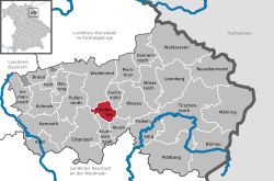 | ||
| Coordinates: 49°52′N 12°07′E / 49.867°N 12.117°ECoordinates: 49°52′N 12°07′E / 49.867°N 12.117°E | ||
| Country | Germany | |
| State | Bavaria | |
| Admin. region | Oberpfalz | |
| District | Tirschenreuth | |
| Government | ||
| • Mayor | Gottfried Härtl (CSU) | |
| Area | ||
| • Total | 16.28 km2 (6.29 sq mi) | |
| Population (2015-12-31)[1] | ||
| • Total | 1,263 | |
| • Density | 78/km2 (200/sq mi) | |
| Time zone | CET/CEST (UTC+1/+2) | |
| Postal codes | 95688 | |
| Dialling codes | 09683 | |
| Vehicle registration | TIR | |
| Website | www.friedenfels.de | |

Friedenfels is a municipality in the district of Tirschenreuth in Bavaria, Germany.
Towns and municipalities in Tirschenreuth | ||
|---|---|---|
References
- ↑ "Fortschreibung des Bevölkerungsstandes". Bayerisches Landesamt für Statistik und Datenverarbeitung (in German). June 2016.
This article is issued from Wikipedia - version of the 11/28/2015. The text is available under the Creative Commons Attribution/Share Alike but additional terms may apply for the media files.