Gasselte
| Gasselte | ||
|---|---|---|
| Town | ||
|
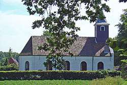
Church of Gasselte | ||
| ||
 | ||
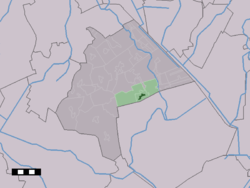 The town centre (dark green) and the statistical district (light green) of Gasselte in the municipality of Aa en Hunze. | ||
| Coordinates: 52°58′19″N 6°47′32″E / 52.97194°N 6.79222°ECoordinates: 52°58′19″N 6°47′32″E / 52.97194°N 6.79222°E | ||
| Country | Netherlands | |
| Province | Drenthe | |
| Municipality | Aa en Hunze | |
| Population (1 January 2008) | ||
| • Total | 1,621 | |
| Time zone | CET (UTC+1) | |
| • Summer (DST) | CEST (UTC+2) | |
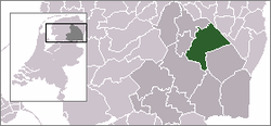
Gasselte is a town in the Dutch province of Drenthe. It is a part of the municipality of Aa en Hunze, and it is situated about 16 km east of Assen.
Gasselte was a separate municipality until 1998, when it became a part of Aa en Hunze.[1]
In 2001, the town of Gasselte had 1081 inhabitants. The built-up area of the town was 0.49 km², and contained 513 residences.[2] The statistical area "Gasselte", which can also include the surrounding countryside, has a population of around 1640.[3]
References
- ↑ Ad van der Meer and Onno Boonstra, "Repertorium van Nederlandse gemeenten", KNAW, 2006.
- ↑ Statistics Netherlands (CBS), Bevolkingskernen in Nederland 2001. (Statistics are for the continuous built-up area).
- ↑ Statistics Netherlands (CBS), Statline: Kerncijfers wijken en buurten 2003-2005. As of 1 January 2005.
External links
- J. Kuyper, Gemeente Atlas van Nederland, 1865-1870, "Gasselte". Map of the former municipality in 1868.
This article is issued from Wikipedia - version of the 2/18/2015. The text is available under the Creative Commons Attribution/Share Alike but additional terms may apply for the media files.