Gazzola
| Gazzola | |
|---|---|
| Comune | |
| Comune di Gazzola | |
 Gazzola Location of Gazzola in Italy | |
| Coordinates: 44°58′N 9°33′E / 44.967°N 9.550°ECoordinates: 44°58′N 9°33′E / 44.967°N 9.550°E | |
| Country | Italy |
| Region | Emilia-Romagna |
| Province / Metropolitan city | Province of Piacenza (PC) |
| Area | |
| • Total | 44.1 km2 (17.0 sq mi) |
| Population (Dec. 2004) | |
| • Total | 1,856 |
| • Density | 42/km2 (110/sq mi) |
| Time zone | CET (UTC+1) |
| • Summer (DST) | CEST (UTC+2) |
| Postal code | 29010 |
| Dialing code | 0523 |
Gazzola is a comune (municipality) in the Province of Piacenza in the Italian region Emilia-Romagna, located about 150 kilometres (93 mi) northwest of Bologna and about 15 kilometres (9 mi) southwest of Piacenza. As of 31 December 2004, it had a population of 1,856 and an area of 44.1 square kilometres (17.0 sq mi).[1]
Gazzola borders the following municipalities: Agazzano, Gossolengo, Gragnano Trebbiense, Piozzano, Rivergaro, Travo.
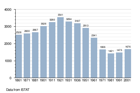
Demographic evolution
References
External links
This article is issued from Wikipedia - version of the 3/17/2014. The text is available under the Creative Commons Attribution/Share Alike but additional terms may apply for the media files.