Gordonville, Texas
| Gordonville | |
|---|---|
| Unincorporated community | |
 Gordonville  Gordonville Location within the state of Texas | |
| Coordinates: 33°47′44″N 96°51′10″W / 33.79556°N 96.85278°WCoordinates: 33°47′44″N 96°51′10″W / 33.79556°N 96.85278°W | |
| Country | United States |
| State | Texas |
| County | Grayson |
| Area | |
| • Unincorporated community | 27.77 sq mi (71.9 km2) |
| • Land | 22.63 sq mi (58.6 km2) |
| • Water | 5.14 sq mi (13.3 km2) |
| • Metro | 979 sq mi (2,536 km2) |
| Population (2010) | |
| • Unincorporated community | 1,714 [1] |
| • Density | 76/sq mi (29/km2) |
| • Metro | 120,877 |
| • Metro density | 130/sq mi (50/km2) |
| Time zone | Central (CST) (UTC-6) |
| • Summer (DST) | CDT (UTC-5) |
| ZIP codes | 76245 |
| Area code(s) | 903 |
Gordonville is a small unincorporated community in Grayson County, Texas, United States. The community is named for Missouri bushwhacker Silas M. Gordon who operated a store there. It is also a part of the Sherman–Denison Metropolitan Statistical Area.
References
External links
Municipalities and communities of Grayson County, Texas, United States | ||
|---|---|---|
| Cities | 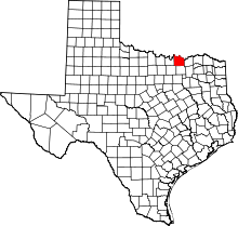 | |
| Towns | ||
| CDPs |
| |
| Other unincorporated communities | ||
| Footnotes | ‡This populated place also has portions in an adjacent county or counties | |
This article is issued from Wikipedia - version of the 7/30/2016. The text is available under the Creative Commons Attribution/Share Alike but additional terms may apply for the media files.