Grotto Mountain
| Grotto Mountain | |
|---|---|
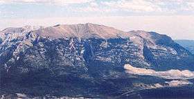 Grotto Mountain from Ha Ling Peak, 2005 | |
| Highest point | |
| Elevation | 2,706 m (8,878 ft) |
| Prominence | 238 m (781 ft) |
| Coordinates | 51°05′00″N 115°16′00″W / 51.08333°N 115.26667°W |
| Geography | |
| Location | Alberta, Canada |
| Parent range | Fairholme Range |
| Topo map | NTS 82O/03 |
| Climbing | |
| First ascent | 1858 by Eugène Bourgeau |
| Easiest route | Scramble |
Grotto Mountain is a mountain located in the Bow River valley, across from Canmore, Alberta, Canada. It is a popular hiking spot among locals and is home to the Rat's Nest Cave.
There are two main scrambling routes:
- Northwest Variation - from the ACC clubhouse, ascends the northwest side of the mountain on a good hiking trail. At tree line, the trail narrows to the false summit. From there, it is a gradual ascent to the summit with brief stints of scrambling but mostly hiking.
- Direct route. Ascends directly under the summit. Shorter but more arduous.
External links
- "Grotto Mountain". Bivouac.com.
- "Grotto Mountain". PeakFinder.com.
This article is issued from Wikipedia - version of the 12/24/2012. The text is available under the Creative Commons Attribution/Share Alike but additional terms may apply for the media files.