Hites Run, Kentucky
| Hites Run, Kentucky | |
|---|---|
| Unincorporated community | |
 Hites Run, Kentucky | |
| Coordinates: 37°49′53″N 86°33′23.5″W / 37.83139°N 86.556528°WCoordinates: 37°49′53″N 86°33′23.5″W / 37.83139°N 86.556528°W | |
| Country | United States |
| State | Kentucky |
| County | Breckinridge |
| Elevation | 381 ft (116 m) |
| Time zone | Central (CST) (UTC-6) |
| • Summer (DST) | CDT (UTC-5) |
| Area code(s) | 270 & 364 |
| GNIS feature ID | 494317[1] |
Hites Run, Kentucky is a town in Breckinridge County, Kentucky.
A man named Hites, who represented the federal government in the early 19th century, made a land survey and the community and creek were named for him.
References
External links
Municipalities and communities of Breckinridge County, Kentucky, United States | ||
|---|---|---|
| Cities | 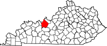 | |
| Unincorporated communities | ||
| Footnotes | ‡This populated place also has portions in an adjacent county or counties | |
This article is issued from Wikipedia - version of the 2/27/2015. The text is available under the Creative Commons Attribution/Share Alike but additional terms may apply for the media files.