Jelloway, Ohio
| Jelloway, Ohio | |
|---|---|
| Unincorporated community | |
|
Zion Lutheran Church in Jelloway | |
 Jelloway, Ohio | |
| Coordinates: 40°32′12″N 82°18′01″W / 40.53667°N 82.30028°WCoordinates: 40°32′12″N 82°18′01″W / 40.53667°N 82.30028°W | |
| Country | United States |
| State | Ohio |
| County | Knox |
| Elevation | 1,043 ft (318 m) |
| Time zone | Eastern (EST) (UTC-5) |
| • Summer (DST) | EDT (UTC-4) |
| Area code(s) | 740 |
| GNIS feature ID | 1064905[1] |
.jpg)
Jelloway is an unincorporated community in Jefferson Township, Knox County, Ohio, United States. Jelloway is located at the junction of Ohio State Route 3 and Ohio State Route 205, 14 miles (23 km) northeast of Mount Vernon.[2]
History
Jelloway was originally called Brownsville, and under the latter name was laid out in 1840.[2] The present name comes from nearby Jelloway Creek.[2] A post office called Jelloway was established in 1842, and remained in operation until 1918.[3]
References
- ↑ "Jelloway". Geographic Names Information System. United States Geological Survey.
- 1 2 3 Graham, Albert Adams (1881). History of Knox County, Ohio: Its Past and Present, Containing a Condensed, Comprehensive History of Ohio. A. A. Graham & Company. p. 429.
- ↑ "Knox County". Jim Forte Postal History. Retrieved 29 December 2015.
External links
![]() Media related to Jelloway, Ohio at Wikimedia Commons
Media related to Jelloway, Ohio at Wikimedia Commons
Municipalities and communities of Knox County, Ohio, United States | ||
|---|---|---|
| City | 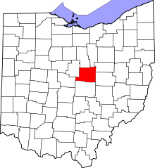 | |
| Villages | ||
| Townships | ||
| CDPs | ||
| Unincorporated communities | ||
| Ghost town | ||
| Footnotes | ‡This populated place also has portions in an adjacent county or counties | |
This article is issued from Wikipedia - version of the 11/4/2016. The text is available under the Creative Commons Attribution/Share Alike but additional terms may apply for the media files.