Johnson, Arizona
| Johnson, Arizona | |
|---|---|
| Populated place | |
 Johnson  Johnson Location within the state of Arizona | |
| Coordinates: 32°06′11″N 110°03′58″W / 32.10306°N 110.06611°WCoordinates: 32°06′11″N 110°03′58″W / 32.10306°N 110.06611°W | |
| Country | United States |
| State | Arizona |
| County | Cochise |
| Elevation[1] | 4,977 ft (1,517 m) |
| Time zone | Mountain (MST) (UTC-7) |
| • Summer (DST) | MST (UTC-7) |
| Area code(s) | 520 |
| FIPS code | 04-36360 |
| GNIS feature ID | 6470 |
Johnson is a populated place situated in Cochise County, Arizona, on the east side of the Little Dragoon Mountains.[2] The location began as a mining camp, and a post office was established there in 1900, with William De H. Washington as its postmaster.[3] The post office closed in 1929.[4] It has an estimated elevation of 4,977 feet (1,517 m) above sea level.[1]
References
- 1 2 "Feature Detail Report for: Johnson". Geographic Names Information System. United States Geological Survey.
- ↑ "Johnson (in Cochise County, AZ) Populated Place Profile". AZ Hometown Locator. Retrieved November 30, 2016.
- ↑ Barnes, Will Croft (2016). Arizona Place Names. Tucson: Arizona Place Names. p. 226. ISBN 0816534950.
- ↑ "Post Offices, Arizona:Cochise County". postalhistory.com. Archived from the original on November 30, 2016. Retrieved November 30, 2016.
Municipalities and communities of Cochise County, Arizona, United States | ||
|---|---|---|
| Cities | 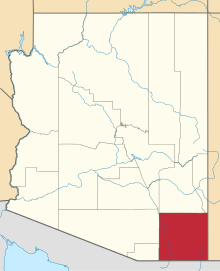 | |
| Towns | ||
| CDPs | ||
| Unincorporated communities |
| |
| Ghost towns |
| |
This article is issued from Wikipedia - version of the 12/1/2016. The text is available under the Creative Commons Attribution/Share Alike but additional terms may apply for the media files.