Keeler Farm, New Mexico
| Keeler Farm, New Mexico | |
|---|---|
| Census-designated place | |
 Keeler Farm, New Mexico | |
| Coordinates: 32°18′58″N 107°45′37″W / 32.31611°N 107.76028°WCoordinates: 32°18′58″N 107°45′37″W / 32.31611°N 107.76028°W | |
| Country | United States |
| State | New Mexico |
| County | Luna |
| Area[1] | |
| • Total | 11.391 sq mi (29.50 km2) |
| • Land | 11.391 sq mi (29.50 km2) |
| • Water | 0 sq mi (0 km2) |
| Elevation | 4,400 ft (1,300 m) |
| Population (2010)[2] | |
| • Total | 1,305 |
| • Density | 110/sq mi (44/km2) |
| Time zone | Mountain (MST) (UTC-7) |
| • Summer (DST) | MDT (UTC-6) |
| Area code(s) | 575 |
| GNIS feature ID | 2584117[3] |
Keeler Farm is a census-designated place in Luna County, New Mexico, United States. Its population was 1,305 as of the 2010 census.[2]
References
- ↑ "US Gazetteer files: 2010, 2000, and 1990". United States Census Bureau. 2011-02-12. Retrieved 2011-04-23.
- 1 2 "American FactFinder". United States Census Bureau. Retrieved 2011-05-14.
- ↑ "Keeler Farm Census Designated Place". Geographic Names Information System. United States Geological Survey.
Municipalities and communities of Luna County, New Mexico, United States | ||
|---|---|---|
| City | 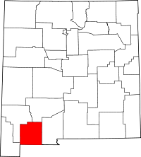 | |
| Village | ||
| CDPs | ||
| Ghost towns | ||
This article is issued from Wikipedia - version of the 7/29/2014. The text is available under the Creative Commons Attribution/Share Alike but additional terms may apply for the media files.