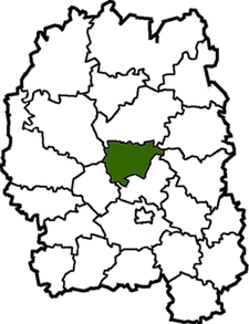
Khoroshiv Raion
| Khoroshiv Raion Хорошівський район | |||
|---|---|---|---|
| Raion | |||
| |||
 | |||
| Coordinates: 50°36′17″N 28°26′41″E / 50.60472°N 28.44472°ECoordinates: 50°36′17″N 28°26′41″E / 50.60472°N 28.44472°E | |||
| Country |
| ||
| Region | Zhytomyr Oblast | ||
| Admin. center | Khoroshiv | ||
| Subdivisions |
List
| ||
| Area | |||
| • Total | 869.8 km2 (335.8 sq mi) | ||
| Population (2013) | |||
| • Total |
| ||
| Time zone | EET (UTC+2) | ||
| • Summer (DST) | EEST (UTC+3) | ||
| Area code | +380 | ||

Khoroshiv Raion (Ukrainian: Хорошівський район), until 2015 Volodarsk-Volynskyi Raion (Ukrainian: Володарськ-Волинський район), is a raion (district) of Zhytomyr Oblast, northern Ukraine. Its administrative centre is located at Khoroshiv. The raion covers an area of 869.8 square kilometres (335.8 sq mi). Population: 35,590 (2013 est.)[1]
On 21 May 2016, Verkhovna Rada adopted decision to rename Volodarsk-Volynskyi Raion to Khoroshiv Raion according to the law prohibiting names of Communist origin.[2] Volodarsk-Volynskyi was previously renamed to Khoroshiv.
References
- ↑ "Чисельність наявного населення України (Actual population of Ukraine)" (in Ukrainian). State Statistics Service of Ukraine. Retrieved 21 January 2015.
- ↑ "Pro perejmenuvannja dejakih naselenih punktіv" (in Ukrainian). Holos Ukrainy. 21 May 2016. Retrieved 1 June 2016.
| Raions | |||||||
|---|---|---|---|---|---|---|---|
| Cities |
| ||||||
| |||||||
This article is issued from Wikipedia - version of the 6/6/2016. The text is available under the Creative Commons Attribution/Share Alike but additional terms may apply for the media files.