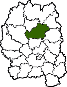
Korosten Raion
| Korosten Raion Коростенський район | ||
|---|---|---|
| Raion | ||
| ||
 | ||
| Coordinates: 50°53′23″N 28°39′45″E / 50.88972°N 28.66250°ECoordinates: 50°53′23″N 28°39′45″E / 50.88972°N 28.66250°E | ||
| Country |
| |
| Region | Zhytomyr Oblast | |
| Admin. center | Korosten | |
| Subdivisions |
List
| |
| Area | ||
| • Total | 1,764 km2 (681 sq mi) | |
| Population (2013) | ||
| • Total |
| |
| Time zone | EET (UTC+2) | |
| • Summer (DST) | EEST (UTC+3) | |
| Area code | +380 | |
Korosten District (Raion) (Ukrainian: Коростенський район) is a raion (district) of Zhytomyr Oblast, northern Ukraine. Its administrative centre is Korosten, which does not belong to the raion and is incorporated separately as a town of oblast significance. The raion covers an area of 1,764 square kilometres (681 sq mi). Population: 28,237 (2013 est.)[1]
References
- ↑ "Чисельність наявного населення України (Actual population of Ukraine)" (in Ukrainian). State Statistics Service of Ukraine. Retrieved 21 January 2015.
External links
| Wikimedia Commons has media related to Korosten Raion. |
| Raions | |||||||
|---|---|---|---|---|---|---|---|
| Cities |
| ||||||
| |||||||
This article is issued from Wikipedia - version of the 1/25/2015. The text is available under the Creative Commons Attribution/Share Alike but additional terms may apply for the media files.