Kodan, Wisconsin
| Kodan, Wisconsin | |
|---|---|
| Unincorporated community | |
 Kodan, Wisconsin  Kodan, Wisconsin | |
| Coordinates: 44°39′40″N 87°29′52″W / 44.66111°N 87.49778°WCoordinates: 44°39′40″N 87°29′52″W / 44.66111°N 87.49778°W | |
| Country | United States |
| State | Wisconsin |
| County | Kewaunee |
| Elevation | 659 ft (201 m) |
| Time zone | Central (CST) (UTC-6) |
| • Summer (DST) | CDT (UTC-5) |
| Area code(s) | 920 |
| GNIS feature ID | 1577681[1] |
Kodan is an unincorporated community located in the town of Ahnapee, Kewaunee County, Wisconsin, United States. Kodan is located on County Highway M near its junction with County Highway D, 4.5 miles (7.2 km) northwest of Algoma.[2]
References
- ↑ U.S. Geological Survey Geographic Names Information System: Kodan, Wisconsin
- ↑ Kewaunee County (PDF) (Map). Wisconsin Department of Transportation. 2011. Retrieved 2011-09-12.
Municipalities and communities of Kewaunee County, Wisconsin, United States | ||
|---|---|---|
| Cities | 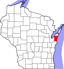 | |
| Villages | ||
| Towns | ||
| CDP | ||
| Unincorporated communities | ||
| Footnotes | ‡This populated place also has portions in an adjacent county or counties | |
This article is issued from Wikipedia - version of the 7/29/2016. The text is available under the Creative Commons Attribution/Share Alike but additional terms may apply for the media files.