Lenora, Oklahoma
| Lenora, Oklahoma | |
|---|---|
| Unincorporated community | |
 Lenora  Lenora Location within the state of Oklahoma | |
| Coordinates: 36°02′28″N 99°03′43″W / 36.04111°N 99.06194°WCoordinates: 36°02′28″N 99°03′43″W / 36.04111°N 99.06194°W | |
| Country | United States |
| State | Oklahoma |
| County | Dewey |
| Elevation | 1,801 ft (549 m) |
| Time zone | Central (CST) (UTC-6) |
| • Summer (DST) | CDT (UTC-5) |
| GNIS feature ID | 1100574 |
Lenora is an unincorporated community in Dewey County, Oklahoma.[1] It is located 5.5 miles west of Taloga.[2] The community was founded in 1892 and had a population of 400 in 1900.[2] A post office operated in Lenora from March 24, 1896 to June 30, 1955.[2]
References
- ↑ U.S. Geological Survey Geographic Names Information System: Lenora, Oklahoma
- 1 2 3 Morris, John Wesley. Ghost Towns of Oklahoma, Norman, OK: University of Oklahoma Press, 1978. p. 120.
Municipalities and communities of Dewey County, Oklahoma, United States | ||
|---|---|---|
| City | 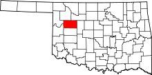 | |
| Towns | ||
| Unincorporated community | ||
This article is issued from Wikipedia - version of the 7/31/2016. The text is available under the Creative Commons Attribution/Share Alike but additional terms may apply for the media files.