Louvale, Georgia
| Louvale, Georgia | |
|---|---|
| Unincorporated community | |
 Louvale, Georgia | |
| Coordinates: 32°10′31″N 84°49′31″W / 32.17528°N 84.82528°WCoordinates: 32°10′31″N 84°49′31″W / 32.17528°N 84.82528°W | |
| Country | United States |
| State | Georgia |
| County | Stewart |
| Elevation | 384 ft (117 m) |
| Time zone | Eastern (EST) (UTC-5) |
| • Summer (DST) | EDT (UTC-4) |
| ZIP code | 31814 |
| Area code(s) | 229 |
| GNIS feature ID | 356369[1] |
Louvale is an unincorporated community in Stewart County, Georgia, United States. The community is located along U.S. Route 27 8.7 miles (14.0 km) north of Lumpkin. Louvale has a post office with ZIP code 31814.[2][3]
References
- ↑ "Louvale". Geographic Names Information System. United States Geological Survey.
- ↑ United States Postal Service. "USPS - Look Up a ZIP Code". Retrieved November 22, 2015.
- ↑ "Postmaster Finder - Post Offices by ZIP Code". United States Postal Service. Retrieved November 22, 2015.
Municipalities and communities of Stewart County, Georgia, United States | ||
|---|---|---|
| Cities | 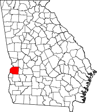 | |
| Unincorporated communities | ||
This article is issued from Wikipedia - version of the 11/22/2015. The text is available under the Creative Commons Attribution/Share Alike but additional terms may apply for the media files.