Highway M19 (Ukraine)
| ||||
|---|---|---|---|---|
| Автошлях M19 | ||||
 | ||||
| Route information | ||||
|
Part of | ||||
| Length: | 503.9 km (313.1 mi) | |||
| Major junctions | ||||
| West end: |
| |||
|
| ||||
| West end: |
| |||
| Location | ||||
| Regions: | Volyn Oblast, Rivne Oblast, Ternopil Oblast, Chernivtsi Oblast | |||
| Highway system | ||||
| ||||

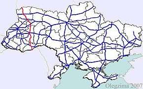
![]() is a Ukrainian international highway (M-highway) connecting the historical region Volhynia (border with Belarus) with the historical region Bukovina (border of Romania) and is part of
is a Ukrainian international highway (M-highway) connecting the historical region Volhynia (border with Belarus) with the historical region Bukovina (border of Romania) and is part of ![]() .[1][2]
.[1][2]
Main route
Main route and connections to/intersections with other highways in Ukraine.
| Marker | Main settlements | Notes | Highway Interchanges |
|---|---|---|---|
| 0 km | Domanove / Border |
||
| Kovel | |||
| Lutsk | H17 • H22 | ||
| Dubno | |||
| Ternopil | |||
| Chernivtsi | H03 • H10 | ||
| 504 km | Porubne / Border |
Gallery
-
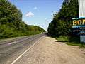
Highway M19 near Lutsk
-

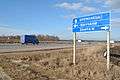
M19 in Volyn Oblast
-
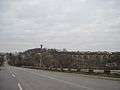
M19 road near Zbarazh
-
An old viaduct near the highway
See also
References
External links
- International Roads in Ukraine in Russian
- European Roads in Russian
| E-roads in Ukraine | ||
|---|---|---|
| International | ||
| National | ||
| Regional |
| |
| ||
This article is issued from Wikipedia - version of the 2/3/2016. The text is available under the Creative Commons Attribution/Share Alike but additional terms may apply for the media files.