Makariv
| Makariv Макарів | |||
|---|---|---|---|
| Village | |||
| |||
| Coordinates: UA 50°27′35″N 29°48′53″E / 50.45972°N 29.81472°ECoordinates: UA 50°27′35″N 29°48′53″E / 50.45972°N 29.81472°E | |||
| Country | Ukraine | ||
| Oblast | Kiev Oblast | ||
| Raion | Makariv Raion | ||
| Founded | 1550 | ||
| Area | |||
| • Total | 62.76 km2 (24.23 sq mi) | ||
| Population | |||
| • Total | 11,860 | ||
| • Density | 190/km2 (490/sq mi) | ||
| Time zone | EET (UTC+2) | ||
| • Summer (DST) | EEST (UTC+3) | ||
| Area code(s) | +380 4578 | ||

Makariv (Ukrainian: Макарів, Russian: Макаров) is an urban-type settlement in Kiev Oblast (province) of Ukraine. It is the administrative center of Makariv Raion. Population: 10,148 (2013 est.)[1]. In 2001, population was 12,042.
The town had a Jewish community and it had been the center of the Hasidic Makarov dynasty, (Makariv being pronounced as "Makarov" in Yiddish.)
Gallery
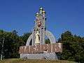 Signpost on the 51th kilometer of the motorway Kyiv-Chop
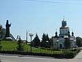 St. Dimitri church and monument on a square next to the local bus station
.jpg) Children and youth art center
Children and youth art center.jpg) Culture house
Culture house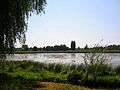 River Zdvyzh in Makariv
References
- ↑ "Чисельність наявного населення України (Actual population of Ukraine)" (in Ukrainian). State Statistics Service of Ukraine. Retrieved 21 January 2015.
| Raions | |||||||
|---|---|---|---|---|---|---|---|
| Cities |
| ||||||
| |||||||
This article is issued from Wikipedia - version of the 10/16/2016. The text is available under the Creative Commons Attribution/Share Alike but additional terms may apply for the media files.