Malhador
| Malhador | |||
|---|---|---|---|
| Municipality | |||
| |||
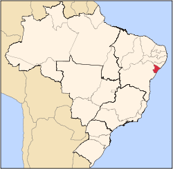
 Malhador Location in Brazil | |||
| Coordinates: 10°39′28″S 37°18′18″W / 10.65778°S 37.30500°WCoordinates: 10°39′28″S 37°18′18″W / 10.65778°S 37.30500°W | |||
| Country |
| ||
| Region | Northeast Region | ||
| State | Sergipe | ||
| Area | |||
| • Total | 101 km2 (39 sq mi) | ||
| Population (2015) | |||
| • Total | 12,598 | ||
| • Density | 120/km2 (320/sq mi) | ||
| Time zone | BRT (UTC-3) | ||
Malhador is a municipality located in the Brazilian state of Sergipe. It is a little city in a rural area. It is located near Itabaiana. Its population was 12,598 (2015) and its area is 101 km².[1]
The municipality contains part of the Serra de Itabaiana National Park.[2]
References
- ↑ IBGE -
- ↑ Unidade de Conservação: Parque Nacional da Serra de Itabaiana (in Portuguese), MMA: Ministério do Meio Ambiente, retrieved 2016-05-03
Capital: Aracaju | |||||||||||||||||||||||||||
| Agreste Sergipano |
|  | |||||||||||||||||||||||||
| Leste Sergipano |
| ||||||||||||||||||||||||||
| Sertao Sergipano |
| ||||||||||||||||||||||||||
This article is issued from Wikipedia - version of the 7/17/2016. The text is available under the Creative Commons Attribution/Share Alike but additional terms may apply for the media files.