Manatí, Atlántico
| Manatí, Atlántico | ||
|---|---|---|
| Municipality and town | ||
 | ||
| ||
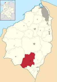 Location of the municipality and town of Manatí in the Department of Atlántico. | ||
| Country | Colombia | |
| Region | Caribbean | |
| Department | Atlántico | |
| Government | ||
| • Mayor | Evaristo Enrique Olivero Pimienta (Liberal Party)[1] | |
| Population (2005) | ||
| • Total | 11,635 | |
| [2] | ||
| Time zone | Colombia Standard Time (UTC-5) | |
| Website |
www.manati-atlantico.gov.co/sitio.shtml | |
.svg.png)
Manatí is a Colombian municipality located to the south of the Atlántico department, approximately 44 miles from Barranquilla. It was created in 1639 in a place the natives used to call Mahabana. Its current population according to the latest DANE’s (Colombian National Administrative Department of Statistics) census is 13.456 people.
References
External links
- (Spanish) Manatí official website
- (Spanish) Manatí website
- (Spanish) Gobernacion del Atlantico - Manatí
Municipalities in the Atlántico Department | ||
|---|---|---|
Coordinates: 10°26′42″N 74°57′35″W / 10.44500°N 74.95972°W
This article is issued from Wikipedia - version of the 9/1/2016. The text is available under the Creative Commons Attribution/Share Alike but additional terms may apply for the media files.