Marion, Pennsylvania
| Marion, Pennsylvania | |
|---|---|
| Census-designated place | |
 Marion Location of Marion in Pennsylvania | |
| Coordinates: 39°51′26″N 77°41′43″W / 39.85722°N 77.69528°WCoordinates: 39°51′26″N 77°41′43″W / 39.85722°N 77.69528°W | |
| Country | United States |
| State | Pennsylvania |
| County | Franklin |
| Township | Guilford |
| Area | |
| • Total | 2.0 sq mi (5.1 km2) |
| • Land | 2.0 sq mi (5.1 km2) |
| • Water | 0.0 sq mi (0.0 km2) |
| Elevation[1] | 633 ft (193 m) |
| Population (2010) | |
| • Total | 953 |
| • Density | 482/sq mi (186.1/km2) |
| Time zone | Eastern (EST) (UTC-5) |
| • Summer (DST) | EDT (UTC-4) |
| ZIP code | 17235 |
| Area code(s) | 717 |
| FIPS code | 42-47464 |
| GNIS feature ID | 1180410[1] |
| [2] | |
Marion is an unincorporated community and census-designated place (CDP) in Franklin County, Pennsylvania, United States. As of the 2010 census the population was 953.[3]
It lies along U.S. Route 11 6 miles (10 km) south of Chambersburg and 5 miles (8 km) north of Greencastle. Interstate 81 passes along the eastern edge of the community, with access from Exit 10 (Pennsylvania Route 914). I-81 leads northeast 37 miles (60 km) to Carlisle and south 17 miles (27 km) to Hagerstown, Maryland.
References
- 1 2 U.S. Geological Survey Geographic Names Information System: Marion Pennsylvania. Retrieved on 2009-06-17.
- ↑ "Marion PA". Zip Code Lookup. Retrieved 2009-06-17.
- ↑ "Geographic Identifiers: 2010 Census Summary File 1 (G001), Marion CDP, Pennsylvania". American FactFinder. U.S. Census Bureau. Retrieved August 12, 2016.
Municipalities and communities of Franklin County, Pennsylvania, United States | ||
|---|---|---|
| Boroughs | 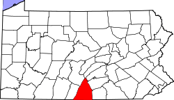 | |
| Townships | ||
| CDPs | ||
| Unincorporated communities | ||
| Footnotes | ‡This populated place also has portions in an adjacent county or counties | |
This article is issued from Wikipedia - version of the 8/12/2016. The text is available under the Creative Commons Attribution/Share Alike but additional terms may apply for the media files.