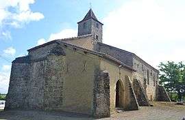
Maulichères
| Maulichères | |
|---|---|
 | |
 Maulichères | |
|
Location within Occitanie region  Maulichères | |
| Coordinates: 43°41′24″N 0°05′20″W / 43.69°N 0.0889°WCoordinates: 43°41′24″N 0°05′20″W / 43.69°N 0.0889°W | |
| Country | France |
| Region | Occitanie |
| Department | Gers |
| Arrondissement | Mirande |
| Canton | Riscle |
| Government | |
| • Mayor (2008–2014) | Yves Portes |
| Area1 | 6.18 km2 (2.39 sq mi) |
| Population (2008)2 | 161 |
| • Density | 26/km2 (67/sq mi) |
| Time zone | CET (UTC+1) |
| • Summer (DST) | CEST (UTC+2) |
| INSEE/Postal code | 32244 / 32400 |
| Elevation |
103–176 m (338–577 ft) (avg. 172 m or 564 ft) |
|
1 French Land Register data, which excludes lakes, ponds, glaciers > 1 km² (0.386 sq mi or 247 acres) and river estuaries. 2 Population without double counting: residents of multiple communes (e.g., students and military personnel) only counted once. | |
Maulichères is a commune in the Gers department in southwestern France.
Geography
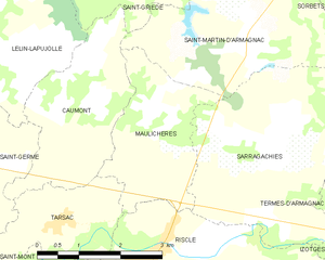
Maulichères and its surrounding communes
Population
| Historical population | ||
|---|---|---|
| Year | Pop. | ±% |
| 1962 | 140 | — |
| 1968 | 179 | +27.9% |
| 1975 | 171 | −4.5% |
| 1982 | 173 | +1.2% |
| 1990 | 207 | +19.7% |
| 1999 | 185 | −10.6% |
| 2008 | 161 | −13.0% |
See also
References
| Wikimedia Commons has media related to Maulichères. |
This article is issued from Wikipedia - version of the 8/16/2016. The text is available under the Creative Commons Attribution/Share Alike but additional terms may apply for the media files.