Mesa del Caballo, Arizona
| Mesa del Caballo, Arizona | |
|---|---|
| Census-designated place | |
 Mesa del Caballo  Mesa del Caballo | |
| Coordinates: 34°17′8″N 111°17′39″W / 34.28556°N 111.29417°WCoordinates: 34°17′8″N 111°17′39″W / 34.28556°N 111.29417°W | |
| Country | United States |
| State | Arizona |
| County | Gila |
| Area | |
| • Total | 0.32 sq mi (0.82 km2) |
| • Land | 0.32 sq mi (0.82 km2) |
| • Water | 0.0 sq mi (0.0 km2) |
| Elevation | 5,170 ft (1,580 m) |
| Population (2010) | |
| • Total | 765 |
| • Density | 2,428/sq mi (937.6/km2) |
| Time zone | MST (no DST) (UTC-7) |
| Area code(s) | 928 |
| FIPS code | 04-46005 |
| GNIS feature ID | 0040822 |
Mesa del Caballo is a census-designated place (CDP) in Gila County, Arizona, United States. The population was 765 at the 2010 census.[1]
Geography
The CDP is located in northern Gila County atop Houston Mesa, a low ridge north of Payson. The center of Payson is 5 miles (8 km) south via Houston Mesa Road and Arizona State Route 87. According to the United States Census Bureau, the CDP has a total area of 0.32 square miles (0.82 km2), all of it land.[1]
References
- 1 2 "Geographic Identifiers: 2010 Demographic Profile Data (G001): Mesa del Caballo CDP, Arizona". U.S. Census Bureau, American Factfinder. Retrieved November 1, 2016.
Municipalities and communities of Gila County, Arizona, United States | ||
|---|---|---|
| City | 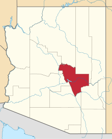 | |
| Towns | ||
| CDPs |
| |
| Unincorporated communities | ||
| Indian reservations | ||
| Ghost towns | ||
| Footnotes | ‡This populated place also has portions in an adjacent county or counties | |
This article is issued from Wikipedia - version of the 11/1/2016. The text is available under the Creative Commons Attribution/Share Alike but additional terms may apply for the media files.