Mezőpeterd
| Mezőpeterd | ||
|---|---|---|
| ||
| Country |
| |
| County | Hajdú-Bihar | |
| Area | ||
| • Total | 18.23 km2 (7.04 sq mi) | |
| Population (2015) | ||
| • Total | 599[1] | |
| • Density | 32.9/km2 (85/sq mi) | |
| Time zone | CET (UTC+1) | |
| • Summer (DST) | CEST (UTC+2) | |
| Postal code | 4118 | |
| Area code(s) | 54 | |

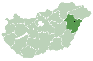
Location of Hajdú-Bihar county in Hungary
Mezőpeterd is a village in Hajdú-Bihar county, in the Northern Great Plain region of eastern Hungary.
Geography
It covers an area of 18.23 km2 (7 sq mi) and has a population of 599 people (2015).[1]
References
- 1 2 Gazetteer of Hungary, 1st January 2015. Hungarian Central Statistical Office. 03/09/2015
County seat: Debrecen | ||
| Cities and towns |  | |
| Villages |
| |
| Other topics |
| |
Coordinates: 47°10′N 21°37′E / 47.167°N 21.617°E
This article is issued from Wikipedia - version of the 5/16/2016. The text is available under the Creative Commons Attribution/Share Alike but additional terms may apply for the media files.