Mildred, Montana
| Mildred, Montana | |
|---|---|
| Unincorporated community | |
 Mildred, Montana  Mildred, Montana | |
| Coordinates: 46°40′33″N 104°57′36″W / 46.67583°N 104.96000°WCoordinates: 46°40′33″N 104°57′36″W / 46.67583°N 104.96000°W | |
| Country | United States |
| State | Montana |
| County | Prairie |
| Elevation | 2,359 ft (719 m) |
| Time zone | Mountain (MST) (UTC-7) |
| • Summer (DST) | MDT (UTC-6) |
| ZIP code | 59341[1] |
| Area code(s) | 406 |
| GNIS feature ID | 774199[2] |

Welcome to Mildred (Montana)
Mildred is an unincorporated community in Prairie County, Montana, United States. Mildred is located along a former Chicago, Milwaukee, St. Paul and Pacific Railroad line 18.5 miles (29.8 km) east-southeast of Terry.
References
- ↑ United States Postal Service (2012). "USPS - Look Up a ZIP Code". Retrieved 2012-02-15.
- ↑ "Mildred". Geographic Names Information System. United States Geological Survey.
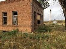
Abandoned bank and church in Midred, MT
Municipalities and communities of Prairie County, Montana, United States | ||
|---|---|---|
| Town | 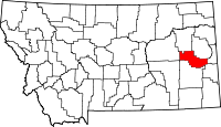 | |
| CDPs | ||
| Unincorporated communities | ||
This article is issued from Wikipedia - version of the 9/15/2016. The text is available under the Creative Commons Attribution/Share Alike but additional terms may apply for the media files.