Mount Stuart, Queensland
| Mount Stuart | |
|---|---|
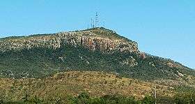 Mount Stuart, overlooking Townsville, Queensland. | |
| Highest point | |
| Elevation | 584 m (1,916 ft) |
| Coordinates | 19°20′S 146°46′E / 19.333°S 146.767°E |
| Geography | |
| Location | Queensland, Australia |
| Climbing | |
| Easiest route | Bitumen road. |
.
Mount Stuart is located in Queensland, Australia, overlooking Townsville with an elevation of 584 metres.
It was named for Clarendon Stuart (1833–1912), from 1859 Townsville's first district surveyor.[1]
Mount Stuart is used for commercial and ABC Queensland television transmission, it was also used as a Bureau of Meteorology radar station until late 2011, where it was moved to Hervey Range.
Mount Stuart overlooks Townsville's Lavarack Barracks a major military base, which consists of 1 RAR, 2 RAR, 3 RAR, 2 CAV, 3/4 CAV, 3 CER, 1 MP Bn, 3 CSSB amongst others.
Mount Stuart is a popular outdoor recreational area, including trail running, mountain biking and rock climbing. Mount Stuart climbing guide
References
Coordinates: 19°20′S 146°46′E / 19.333°S 146.767°E