Neavitt, Maryland
| Neavitt, Maryland | |
|---|---|
| Unincorporated community | |
 Neavitt | |
| Coordinates: 38°43′28″N 76°16′57″W / 38.72444°N 76.28250°WCoordinates: 38°43′28″N 76°16′57″W / 38.72444°N 76.28250°W | |
| Country | United States |
| State | Maryland |
| County | Talbot |
| Elevation | 7 ft (2 m) |
| Time zone | Eastern (EST) (UTC-5) |
| • Summer (DST) | EDT (UTC-4) |
| ZIP code | 21652 |
| Area code(s) | 410, 443, and 667 |
| GNIS feature ID | 590866[1] |
Neavitt is an unincorporated community in Talbot County, Maryland, United States.[1] Neavitt is located at the southern terminus of Maryland Route 579 on the north bank of the Choptank River south-southwest of St. Michaels and northeast of Tilghman Island.
References
Municipalities and communities of Talbot County, Maryland, United States | ||
|---|---|---|
| Towns | 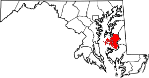 | |
| CDPs | ||
| Other communities | ||
| Footnotes | ‡This populated place also has portions in an adjacent county or counties | |
This article is issued from Wikipedia - version of the 10/28/2016. The text is available under the Creative Commons Attribution/Share Alike but additional terms may apply for the media files.