Nesselwängle
| Nesselwängle | ||
|---|---|---|
 | ||
| ||
 Nesselwängle Location within Austria | ||
Location within Reutte district
| ||
| Coordinates: 47°29′00″N 10°37′00″E / 47.48333°N 10.61667°ECoordinates: 47°29′00″N 10°37′00″E / 47.48333°N 10.61667°E | ||
| Country | Austria | |
| State | Tyrol | |
| District | Reutte | |
| Government | ||
| • Mayor | Klaus Hornstein | |
| Area | ||
| • Total | 23.02 km2 (8.89 sq mi) | |
| Elevation | 1,136 m (3,727 ft) | |
| Population (1 January 2016)[1] | ||
| • Total | 456 | |
| • Density | 20/km2 (51/sq mi) | |
| Time zone | CET (UTC+1) | |
| • Summer (DST) | CEST (UTC+2) | |
| Postal code | 6672 | |
| Area code | 05675 | |
| Vehicle registration | RE | |

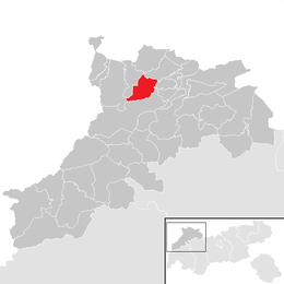
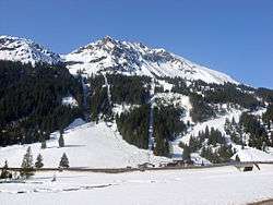
Nesselwängle is a municipality in the district of Reutte in the Austrian state of Tyrol.
Geography
Nesselwängle lies at the entrance to the Tannheim valley.
References
External links
- Official website (German)
- Website of the skiing area Nesselwängle (German)
| Wikimedia Commons has media related to Nesselwängle. |
This article is issued from Wikipedia - version of the 6/10/2016. The text is available under the Creative Commons Attribution/Share Alike but additional terms may apply for the media files.