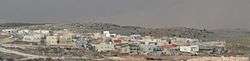
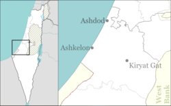
Neta, Israel
| Neta | |
|---|---|
 | |
 Neta | |
| Coordinates: 31°28′42″N 34°55′35″E / 31.47833°N 34.92639°ECoordinates: 31°28′42″N 34°55′35″E / 31.47833°N 34.92639°E | |
| District | Southern |
| Council | Lakhish |
| Affiliation | Amana |
| Founded | 2012 |
| Population (2015)[1] | 453 |
Neta (Hebrew: נֶטַע, lit. Seedling) is a community settlement in south-central Israel. Located next to the Green Line, it falls under the jurisdiction of Lakhish Regional Council. In 2015 it had a population of 453.
History
The village was established in 2012 by former residents of the Kfar Darom and Tel Katifa Israeli settlements in the Gaza Strip,[2] which had been evacuated as part of the Israeli disengagement from Gaza. Following the disengagement in 2005, they had temporarily lived in Ashkelon until the new village was ready.
References
- ↑ "List of localities, in Alphabetical order" (PDF). Israel Central Bureau of Statistics. Retrieved 16 October 2016.
- ↑ Neta Katif Center
This article is issued from Wikipedia - version of the 9/16/2016. The text is available under the Creative Commons Attribution/Share Alike but additional terms may apply for the media files.