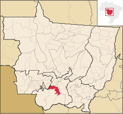
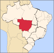
Nossa Senhora do Livramento, Mato Grosso
Nossa Senhora do Livramento is a municipality in the state of Mato Grosso, Brazil. The population is 11,393 (2015 est.) in an area of 5076.78 km².[1] Its elevation is 232 m.
References
External links
|
|---|
|
|
|
| Centro-Sul Mato-Grossense | Alto Pantanal | |
|---|
| Alto Paraguai | |
|---|
| Cuiabá | |
|---|
| Rosario Oeste | |
|---|
| |
|---|
|
| Nordeste Mato-Grossense | Canarana | |
|---|
| Medio Araguaia | |
|---|
| Norte Araguaia | |
|---|
|
|---|
|
| Norte Mato-Grossense | Alta Floresta | |
|---|
| Alto Teles Pires | |
|---|
| Arinos | |
|---|
| Aripuanã | |
|---|
| Colíder | |
|---|
| Paranatinga | |
|---|
| Parecis | |
|---|
| Sinop | |
|---|
|
|---|
|
| Sudeste Mato-Grossense | Alto Araguaia | |
|---|
| Primavera do Leste | |
|---|
| Rondonópolis | |
|---|
| Tesouro | |
|---|
|
|---|
|
| Sudoeste Mato-Grossense | Alto Guapore | |
|---|
| Jauru | |
|---|
| Tangará da Serra | |
|---|
|
|---|