Old Columbine, Arizona
| Old Columbine, Arizona | |
|---|---|
| Unincorporated community | |
 Old Columbine  Old Columbine | |
| Coordinates: 32°42′26″N 109°54′34″W / 32.70722°N 109.90944°WCoordinates: 32°42′26″N 109°54′34″W / 32.70722°N 109.90944°W | |
| Country | United States |
| State | Arizona |
| County | Graham |
| Elevation | 9,360 ft (2,850 m) |
| Time zone | Mountain (MST) (UTC-7) |
| Area code(s) | 928 |
| GNIS feature ID | 8941[1] |
Old Columbine is an unincorporated community in Graham County, Arizona, United States. Old Columbine is located in a mountainous area 14.6 miles (23.5 km) southwest of Safford by air.
References
Municipalities and communities of Graham County, Arizona, United States | ||
|---|---|---|
| City | 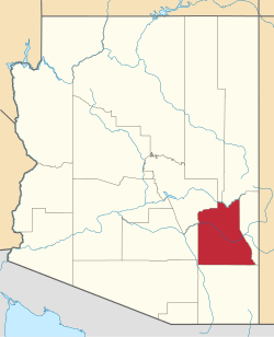 | |
| Towns | ||
| CDPs | ||
| Unincorporated communities | ||
| Indian reservations | ||
| Ghost towns | ||
| Footnotes | ‡This populated place also has portions in an adjacent county or counties | |
This article is issued from Wikipedia - version of the 11/9/2016. The text is available under the Creative Commons Attribution/Share Alike but additional terms may apply for the media files.