Otepää Parish
| Otepää Parish Otepää vald | |||
|---|---|---|---|
| Municipality of Estonia | |||
|
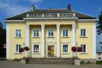
Otepää Cultural Building | |||
| |||
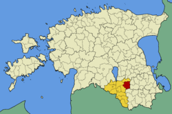 Otepää Parish within Valga County. | |||
| Country |
| ||
| County |
| ||
| Administrative centre | Otepää | ||
| Government | |||
| • Vallavanem | Kuldar Veere | ||
| Area | |||
| • Total | 217.36 km2 (83.92 sq mi) | ||
| Population (1st January, 2013) | |||
| • Total | 4,091 | ||
| • Density | 19/km2 (49/sq mi) | ||
| Website | www.otepaa.ee | ||


Otepää Parish (Estonian: Otepää vald) is a rural municipality in Valga County, southern Estonia. It includes the town of Otepää.
Settlements
- Town
- Villages
Arula - Ilmjärve - Kääriku - Kassiratta - Kastolatsi - Kaurutootsi - Koigu - Mägestiku - Mäha - Märdi - Nüpli - Otepää - Pedajamäe - Pilkuse - Pühajärve - Raudsepa - Sihva - Tõutsi - Truuta - Vana-Otepää - Vidrike
External links
Coordinates: 58°03′N 26°29′E / 58.050°N 26.483°E
| Urban municipalities | ||
|---|---|---|
| Rural municipalities | ||
This article is issued from Wikipedia - version of the 5/24/2016. The text is available under the Creative Commons Attribution/Share Alike but additional terms may apply for the media files.