Overton, Virginia
| Overton | |
|---|---|
| Unincorporated community | |
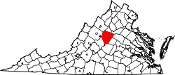
 Overton  Overton Location within the Commonwealth of Virginia | |
| Coordinates: 37°57′26″N 78°28′4″W / 37.95722°N 78.46778°WCoordinates: 37°57′26″N 78°28′4″W / 37.95722°N 78.46778°W | |
| Country | United States |
| State | Virginia |
| County | Albemarle |
| Elevation | 505 ft (154 m) |
| Time zone | Eastern (EST) (UTC-5) |
| • Summer (DST) | EDT (UTC-4) |
| GNIS feature ID | 1477599[1] |
Overton is an unincorporated community in Albemarle County, Virginia. Its elevation is 505 feet (154 m).[1]
References
- 1 2 "Overton". Geographic Names Information System. United States Geological Survey. Retrieved August 12, 2013.
This article is issued from Wikipedia - version of the 7/27/2016. The text is available under the Creative Commons Attribution/Share Alike but additional terms may apply for the media files.