Packs Branch, West Virginia
| Packs Branch, West Virginia | |
|---|---|
| Unincorporated community | |
 Packs Branch  Packs Branch | |
| Coordinates: 37°54′19″N 81°14′4″W / 37.90528°N 81.23444°WCoordinates: 37°54′19″N 81°14′4″W / 37.90528°N 81.23444°W | |
| Country | United States |
| State | West Virginia |
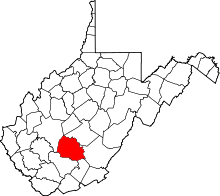
| County | Fayette |
| Elevation | 1,729 ft (527 m) |
| Time zone | Eastern (EST) (UTC-5) |
| • Summer (DST) | EDT (UTC-4) |
| GNIS ID | 1544505[1] |
Packs Branch is an unincorporated community in Fayette County, West Virginia.It was also called O'Neals.
The community was named after nearby Packs Branch.[2]
References
- ↑ U.S. Geological Survey Geographic Names Information System: Packs Branch, West Virginia
- ↑ Kenny, Hamill (1945). West Virginia Place Names: Their Origin and Meaning, Including the Nomenclature of the Streams and Mountains. Piedmont, WV: The Place Name Press. p. 476.
This article is issued from Wikipedia - version of the 10/25/2016. The text is available under the Creative Commons Attribution/Share Alike but additional terms may apply for the media files.