Pocenia
| Pocenia | |
|---|---|
| Comune | |
| Comune di Pocenia | |
 Pocenia Location of Pocenia in Italy | |
| Coordinates: 45°50′N 13°6′E / 45.833°N 13.100°ECoordinates: 45°50′N 13°6′E / 45.833°N 13.100°E | |
| Country | Italy |
| Region | Friuli-Venezia Giulia |
| Province / Metropolitan city | Province of Udine (UD) |
| Frazioni | Torsa, Roveredo, Paradiso |
| Area | |
| • Total | 23.9 km2 (9.2 sq mi) |
| Elevation | 9 m (30 ft) |
| Population (Dec. 2004) | |
| • Total | 2,581 |
| • Density | 110/km2 (280/sq mi) |
| Time zone | CET (UTC+1) |
| • Summer (DST) | CEST (UTC+2) |
| Postal code | 33050 |
| Dialing code | 0432 |
| Website | Official website |
Pocenia is a comune (municipality) in the Province of Udine in the Italian region Friuli-Venezia Giulia, located about 60 kilometres (37 mi) northwest of Trieste and about 30 kilometres (19 mi) southwest of Udine. As of 31 December 2004, it had a population of 2,581 and an area of 23.9 square kilometres (9.2 sq mi).[1]
The municipality of Pocenia contains the frazioni (subdivisions, mainly villages and hamlets) Torsa, Roveredo, and Paradiso.
Pocenia borders the following municipalities: Castions di Strada, Muzzana del Turgnano, Palazzolo dello Stella, Rivignano, Talmassons, Teor.
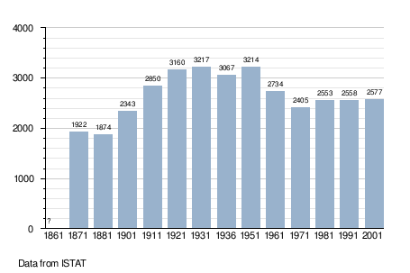
Demographic evolution
References
External links
This article is issued from Wikipedia - version of the 1/31/2015. The text is available under the Creative Commons Attribution/Share Alike but additional terms may apply for the media files.