Poy Sippi (CDP), Wisconsin
| Poy Sippi | |
|---|---|
| Census-designated place | |
|
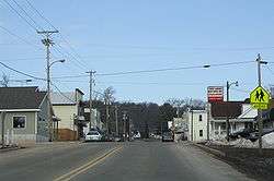
Looking north at downtown Poy Sippi | |
| Coordinates: 44°08′14″N 88°59′43″W / 44.13722°N 88.99528°WCoordinates: 44°08′14″N 88°59′43″W / 44.13722°N 88.99528°W | |
| Country | United States |
| State | Wisconsin |
| County | Waushara |
| Area | |
| • Total | 0.757 sq mi (1.96 km2) |
| • Land | 0.728 sq mi (1.89 km2) |
| • Water | 0.029 sq mi (0.08 km2) |
| Population (2010) | |
| • Total | 371 |
| • Density | 490/sq mi (190/km2) |
| Time zone | Central (CST) (UTC-6) |
| • Summer (DST) | CDT (UTC-5) |
| ZIP codes | 54967 |
| Area code(s) | 920 |
Poy Sippi is an unincorporated census-designated place in the town of Poy Sippi in Waushara County, Wisconsin, United States. It is located at the intersection of Wisconsin Highway 49 and County H.[1] As of the 2010 census, its population is 371.[2]
Images
 The sign for Poy Sippi
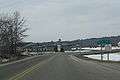
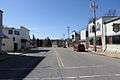 Looking south on WIS 49
References
| Wikimedia Commons has media related to Poy Sippi, Wisconsin. |
- ↑ "Location of Poy Sippi". Mapquest. Retrieved 20 April 2010.
- ↑ "American FactFinder". U.S. Census Bureau. Retrieved 19 April 2011.
Municipalities and communities of Waushara County, Wisconsin, United States | ||
|---|---|---|
| Cities | 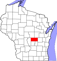 | |
| Villages | ||
| Towns | ||
| CDPs | ||
| Unincorporated communities | ||
| Ghost town | ||
| Footnotes | ‡This populated place also has portions in an adjacent county or counties | |
This article is issued from Wikipedia - version of the 9/5/2016. The text is available under the Creative Commons Attribution/Share Alike but additional terms may apply for the media files.