Prestvannet
| Prestvannet | |
|---|---|
 View of Prestvannet lake | |
| Location | Tromsøya island |
| Coordinates | 69°39′33″N 18°56′9″E / 69.65917°N 18.93583°ECoordinates: 69°39′33″N 18°56′9″E / 69.65917°N 18.93583°E |
| Type | Historic reservoir |
| Basin countries | Norway |
| Max. length | 400 m (1,300 ft) |
| Max. width | 300 m (980 ft) |
| Shore length1 | 1.3 km (4,300 ft) |
| Surface elevation | 96 m (315 ft) |
| Settlements | Tromsø |
| References | yr.no[1] |
| 1 Shore length is not a well-defined measure. | |
Prestvannet is a small lake on the highest point on the central part of the island of Tromsøya in the city of Tromsø in Troms county, Norway. Prestvannet was built up as a reservoir in 1867, and continued in that function until 1921. Since then it has been used as park land and a nature reserve.
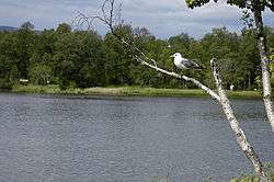
The pond area, just next to a big city has been preserved as a nesting place for various birds. The pond and its surrounding wooded area is an important natural area for the Tromsø area. Encircling the pond, is a track commonly used for recreational activities and sports, as well as a nature trail with plaques informing about the local wildlife. In the winter, the frozen pond is a popular place for ice skating.
Media gallery
 Prestvannet during winter.
 View towards southwest. The tall mountain in the background is Middagstind on Kvaløya.
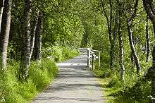 Nature path near Prestvannet
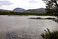 Another view of the lake
References
- ↑ "Prestvannet" (in Norwegian). yr.no. Retrieved 02-04-2010. Check date values in:
|access-date=(help)
This article is issued from Wikipedia - version of the 9/4/2015. The text is available under the Creative Commons Attribution/Share Alike but additional terms may apply for the media files.