Pumpkin Center, Comanche County, Oklahoma
| Pumpkin Center, Oklahoma | |
|---|---|
| Unincorporated community | |
 Pumpkin Center  Pumpkin Center Location within the state of Oklahoma | |
| Coordinates: 34°35′38″N 98°12′43″W / 34.59389°N 98.21194°WCoordinates: 34°35′38″N 98°12′43″W / 34.59389°N 98.21194°W | |
| Country | United States |
| State | Oklahoma |
| County | Comanche |
| Elevation | 1,161 ft (354 m) |
| Time zone | Central (CST) (UTC-6) |
| • Summer (DST) | CDT (UTC-5) |
| FIPS code | 40-61050 |
| GNIS feature ID | 1096955[1] |
Pumpkin Center is an unincorporated community in Comanche County, Oklahoma. It is located at the intersection of State Highway 7 and State Highway 65, about 10 miles east of Lawton, Oklahoma in the southwestern portion of the state.[1]
References
Municipalities and communities of Comanche County, Oklahoma, United States | ||
|---|---|---|
| Cities | 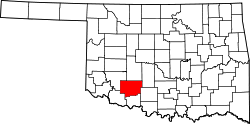 | |
| Towns | ||
| Unincorporated communities | ||
| Footnotes | ‡This populated place also has portions in an adjacent county or counties | |
This article is issued from Wikipedia - version of the 7/31/2016. The text is available under the Creative Commons Attribution/Share Alike but additional terms may apply for the media files.