Quebec Route 301
| ||||
|---|---|---|---|---|
 | ||||
| Route information | ||||
| Maintained by Transports Québec | ||||
| Length: | 81.1 km[1] (50.4 mi) | |||
| Major junctions | ||||
| South end: |
| |||
|
| ||||
| North end: |
| |||
| Location | ||||
| Counties: | Pontiac / La Vallée-de-la-Gatineau | |||
| Highway system | ||||
| ||||

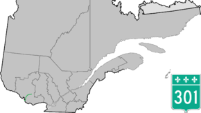
Route 301 is an 81.1-kilometre-long (50.4 mi) provincial highway located in the Outaouais region in western Quebec. The route serves as a direct connection between the Pontiac region and the Upper Gatineau region. The 82-kilometer route runs from the end of Ontario Highway 653 near Portage-du-Fort and joins Route 148 for a 9 km (5.6 mi) stretch up to Campbell's Bay where it continues eastward and ends in Kazabazua at the junction of Route 105.
Municipalities along Highway 301
Major intersections
| RCM or ET | Municipality | Km | Junction | Notes |
|---|---|---|---|---|
Southern terminus of Route 301 | ||||
| Pontiac | Portage-du-Fort | 0.0 | 653 WEST: to Chenaux, Ontario | |
| 1.5 | 303 NORTH: to Shawville | |||
| Litchfield | 10.3 | 148 WEST: to Clarendon | ||
| Bryson | 13.8 | Chemin Wilson | WEST: to L'Île-du-Grand-Calumet | |
| Campbell's Bay | 20.4 | 148 EAST: to Litchfield | ||
| Thorne | 34.9 | 366 EAST: to La Pêche | ||
| Otter Lake | 41.4 | 303 SOUTH: to Thorne | ||
| La Vallée-de-la-Gatineau | Kazabazua | 81.1 | 105 SOUTH: to Low 105 NORTH: to Wright | |
Northern terminus of Route 301 | ||||
See also
References
- ↑ Ministère des transports, "Distances routières", page 95, Les Publications du Québec, 2005
External links
- Provincial Route Map (Courtesy of the Quebec Ministry of Transportation) (French)
- Route 301 on Google Maps
This article is issued from Wikipedia - version of the 11/9/2016. The text is available under the Creative Commons Attribution/Share Alike but additional terms may apply for the media files.