Quinney, Wisconsin
| Quinney, Wisconsin | |
|---|---|
| Unincorporated community | |
|
Looking north at Quinney on WIS 55 | |
 Quinney  Quinney | |
| Coordinates: 44°00′52″N 88°18′26″W / 44.01444°N 88.30722°WCoordinates: 44°00′52″N 88°18′26″W / 44.01444°N 88.30722°W | |
| Country | United States |
| State | Wisconsin |
| County | Calumet |
| Town | Stockbridge |
| Elevation | 869 ft (265 m) |
| Time zone | Central (CST) (UTC-6) |
| • Summer (DST) | CDT (UTC-5) |
| Area code(s) | 920 |
| GNIS feature ID | 1577782[1] |
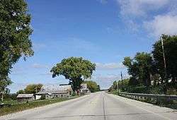
Quinney is an unincorporated community in the town of Stockbridge, Calumet County, Wisconsin, United States.[1] It is located along Wisconsin Highway 55 approximately one mile (1 km) north of its southern terminus. The Military Ridge Road ran through the community.
Notes
Municipalities and communities of Calumet County, Wisconsin, United States | ||
|---|---|---|
| Cities | 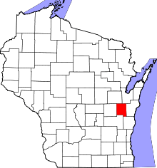 | |
| Villages | ||
| Towns | ||
| CDP | ||
| Unincorporated communities | ||
| Ghost town | ||
| Footnotes | ‡This populated place also has portions in an adjacent county or counties | |
This article is issued from Wikipedia - version of the 7/29/2016. The text is available under the Creative Commons Attribution/Share Alike but additional terms may apply for the media files.