Rubano
| Rubano | |
|---|---|
| Comune | |
| Comune di Rubano | |
 Rubano Location of Rubano in Italy | |
| Coordinates: 45°26′N 11°47′E / 45.433°N 11.783°ECoordinates: 45°26′N 11°47′E / 45.433°N 11.783°E | |
| Country | Italy |
| Region | Veneto |
| Province / Metropolitan city | Province of Padua (PD) |
| Frazioni | Sarmeola, Bosco, Villaguattera |
| Government | |
| • Mayor | Sabrina Doni |
| Area | |
| • Total | 14.6 km2 (5.6 sq mi) |
| Elevation | 16 m (52 ft) |
| Population (Dec. 2011) | |
| • Total | 15,669 |
| • Density | 1,100/km2 (2,800/sq mi) |
| Time zone | CET (UTC+1) |
| • Summer (DST) | CEST (UTC+2) |
| Postal code | 35030 |
| Dialing code | 049 |
| Website | Official website |
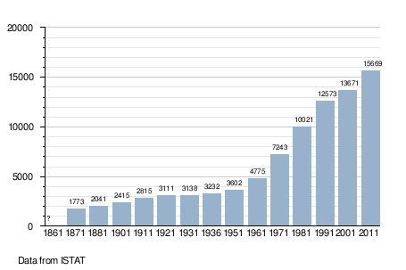
Rubano is a comune (municipality) in the Province of Padua in the Italian region Veneto, located about 40 kilometres (25 mi) west of Venice and about 7 kilometres (4 mi) northwest of Padua. As of 31 December 2011, it had a population of 15,669 and an area of 14.6 square kilometres (5.6 sq mi).[1]
The municipality of Rubano contains the frazioni (subdivisions, mainly villages and hamlets) Sarmeola, Bosco, and Villaguattera.
Rubano borders the following municipalities: Mestrino, Padua, Saccolongo, Selvazzano Dentro, Villafranca Padovana.
Demographic evolution
References
External links
This article is issued from Wikipedia - version of the 8/2/2015. The text is available under the Creative Commons Attribution/Share Alike but additional terms may apply for the media files.