Saccolongo
| Saccolongo | |
|---|---|
| Comune | |
| Comune di Saccolongo | |
 Saccolongo Location of Saccolongo in Italy | |
| Coordinates: 45°24′N 11°45′E / 45.400°N 11.750°ECoordinates: 45°24′N 11°45′E / 45.400°N 11.750°E | |
| Country | Italy |
| Region | Veneto |
| Province / Metropolitan city | Province of Padua (PD) |
| Frazioni | Creòla, Canton della Madonna |
| Area | |
| • Total | 13.7 km2 (5.3 sq mi) |
| Elevation | 19 m (62 ft) |
| Population (Dec. 2004) | |
| • Total | 4,538 |
| • Density | 330/km2 (860/sq mi) |
| Demonym(s) | Saccolongani |
| Time zone | CET (UTC+1) |
| • Summer (DST) | CEST (UTC+2) |
| Postal code | 35030 |
| Dialing code | 049 |
| Website | Official website |
Saccolongo (Venetian: Sacołongo) is a comune (municipality) in the Province of Padua in the Italian region Veneto, located about 45 kilometres (28 mi) west of Venice and about 9 kilometres (6 mi) west of Padua. As of 31 December 2004, it had a population of 4,538 and an area of 13.7 square kilometres (5.3 sq mi).[1]
The municipality of Saccolongo contains the frazioni (subdivisions, mainly villages and hamlets) Creòla and Canton della Madonna.
Saccolongo borders the following municipalities: Cervarese Santa Croce, Mestrino, Rubano, Selvazzano Dentro, Teolo, Veggiano.
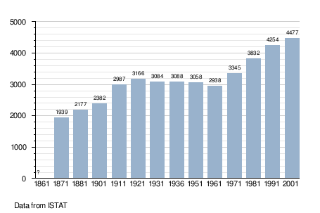
Demographic evolution
References
This article is issued from Wikipedia - version of the 11/30/2016. The text is available under the Creative Commons Attribution/Share Alike but additional terms may apply for the media files.