Sahorre
| Sahorre Saorra | ||
|---|---|---|
|
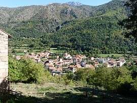
View from the church of Saint-Etienne, to Sahorre and the Canigou | ||
| ||
 Sahorre | ||
|
Location within Occitanie region  Sahorre | ||
| Coordinates: 42°32′00″N 2°21′45″E / 42.5333°N 2.3625°ECoordinates: 42°32′00″N 2°21′45″E / 42.5333°N 2.3625°E | ||
| Country | France | |
| Region | Occitanie | |
| Department | Pyrénées-Orientales | |
| Arrondissement | Prades | |
| Canton | Olette | |
| Government | ||
| • Mayor (2008–2014) | Fabienne Bardon | |
| Area1 | 14.88 km2 (5.75 sq mi) | |
| Population (1999)2 | 347 | |
| • Density | 23/km2 (60/sq mi) | |
| Time zone | CET (UTC+1) | |
| • Summer (DST) | CEST (UTC+2) | |
| INSEE/Postal code | 66166 / 66360 | |
| Elevation |
599–2,082 m (1,965–6,831 ft) (avg. 675 m or 2,215 ft) | |
|
1 French Land Register data, which excludes lakes, ponds, glaciers > 1 km² (0.386 sq mi or 247 acres) and river estuaries. 2 Population without double counting: residents of multiple communes (e.g., students and military personnel) only counted once. | ||

Sahorre (Catalan: Saorra) is a commune in the Pyrénées-Orientales department in southern France.
Geography
Sahorre is in the canton of Olette and in the arrondissement of Prades.
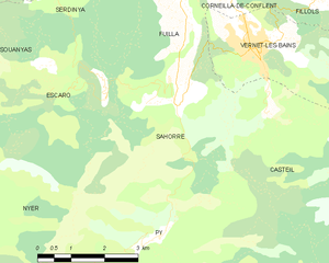
Map of Sahorre and its surrounding communes
Population
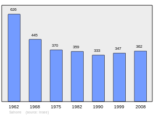
Population 1962-2008
See also
References
| Wikimedia Commons has media related to Sahorre. |
This article is issued from Wikipedia - version of the 1/23/2016. The text is available under the Creative Commons Attribution/Share Alike but additional terms may apply for the media files.