Bouleternère
| Bouleternère Bulaternera | ||
|---|---|---|
|
The round tower in Bouleternère | ||
| ||
 Bouleternère | ||
|
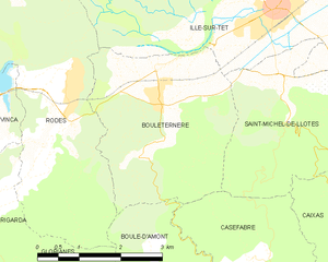
Location within Occitanie region  Bouleternère | ||
| Coordinates: 42°39′02″N 2°35′14″E / 42.6506°N 2.5872°ECoordinates: 42°39′02″N 2°35′14″E / 42.6506°N 2.5872°E | ||
| Country | France | |
| Region | Occitanie | |
| Department | Pyrénées-Orientales | |
| Arrondissement | Prades | |
| Canton | Vinça | |
| Intercommunality | Roussillon Conflent | |
| Government | ||
| • Mayor (2014-2020) | Jean Payrou | |
| Area1 | 10.63 km2 (4.10 sq mi) | |
| Population (2012)2 | 880 | |
| • Density | 83/km2 (210/sq mi) | |
| Time zone | CET (UTC+1) | |
| • Summer (DST) | CEST (UTC+2) | |
| INSEE/Postal code | 66023 / 66130 | |
| Elevation |
160–612 m (525–2,008 ft) (avg. 180 m or 590 ft) | |
|
1 French Land Register data, which excludes lakes, ponds, glaciers > 1 km² (0.386 sq mi or 247 acres) and river estuaries. 2 Population without double counting: residents of multiple communes (e.g., students and military personnel) only counted once. | ||


Bouleternère (Catalan: Bulaternera) is a commune in the Pyrénées-Orientales department in southern France.
Geography
Localisation
Bouleternère is located in the canton of Vinça and in the arrondissement of Prades.
Neighbouring communes
| Ille-sur-Têt | |||
| Rodès | |
Saint-Michel-de-Llotes | |
| |||
| | |||
| Boule-d'Amont | Casefabre |

Hydrography
Bouleternère is crossed by the Boulès river, a tributary of the Têt.
Government and politics
Mayors
| Mayor | Term start | Term end |
|---|---|---|
| Isidore Pontich | 1790 | 1792 |
| Athanase Guiry | 1792 | 1793 |
| François Guimbert | 1793 | 1795 |
| Sulpice Taix | 1795 | 1799 |
| Athanase Guiry | 1799 | June 1815[1] |
| Jean Marmer | June 1815[1] | ? |
| Athanase Guiry | ? | 1821 |
| Joseph Mercure | 1924 | 1924 |
| André Paysa | 1924 | 1927 |
| François Sabardeil | 1927 | 1941 |
| François Baux | 1941 | 1944 |
| François Garrigue | 1944 | 1952 |
| Jules Gaspard | 1952 | 1983 |
| Jean Payrou | 1983 |
Population
| Historical population | ||
|---|---|---|
| Year | Pop. | ±% |
| 1962 | 818 | — |
| 1968 | 885 | +8.2% |
| 1975 | 739 | −16.5% |
| 1982 | 728 | −1.5% |
| 1990 | 625 | −14.1% |
| 1999 | 643 | +2.9% |
| 2007 | 777 | +20.8% |
| 2009 | 817 | +5.1% |
Sites of interest
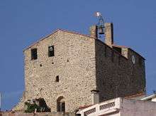
Part of the town's fortifications remain, and two of the four towers and three of the seven city doors are still in place.
The old Saint-Sulpitius church was built in the 11th century on the remains of an older church from the 9th century. A new Saint-Sulpitius church was built next to it and finished in 1659, while the old church became the presbytery. Both were hit by lightning in June 1891 and suffered a serious fire. They have since been repaired.[2]
See also
References
- 1 2 Cardenas, Fabricio (9 February 2014). "Bouleternère, le 1er juin 1815". Vieux papiers des Pyrénées-Orientales (in French). Retrieved 28 February 2016.
- ↑ Cardenas, Fabricio (29 January 2014). "Incendie de l'église de Bouleternère en 1891". Vieux papiers des Pyrénées-Orientales (in French). Retrieved 28 February 2016.
| Wikimedia Commons has media related to Bouleternère. |