Saint-Bonnet-de-Chirac
| Saint-Bonnet-de-Chirac | |
|---|---|
|
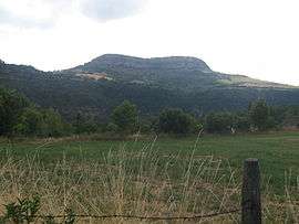
The Truc de Saint-Bonnet-de-Chirac at 942 m (3,091 ft) | |
 Saint-Bonnet-de-Chirac | |
|
Location within Occitanie region  Saint-Bonnet-de-Chirac | |
| Coordinates: 44°30′51″N 3°17′02″E / 44.5142°N 3.2839°ECoordinates: 44°30′51″N 3°17′02″E / 44.5142°N 3.2839°E | |
| Country | France |
| Region | Occitanie |
| Department | Lozère |
| Arrondissement | Mende |
| Canton | Marvejols |
| Intercommunality | Gévaudan |
| Government | |
| • Mayor (2008–2014) | Isabelle Recoulin |
| Area1 | 7.68 km2 (2.97 sq mi) |
| Population (1999)2 | 57 |
| • Density | 7.4/km2 (19/sq mi) |
| Time zone | CET (UTC+1) |
| • Summer (DST) | CEST (UTC+2) |
| INSEE/Postal code | 48138 / 48100 |
| Elevation |
579–960 m (1,900–3,150 ft) (avg. 650 m or 2,130 ft) |
|
1 French Land Register data, which excludes lakes, ponds, glaciers > 1 km² (0.386 sq mi or 247 acres) and river estuaries. 2 Population without double counting: residents of multiple communes (e.g., students and military personnel) only counted once. | |
Saint-Bonnet-de-Chirac is a commune in the Lozère department in southern France.
Geography
The Colagne forms part of the commune's south-western border, then flows into the Lot, which forms part of the commune's southern border.
See also
External links
| Wikimedia Commons has media related to Saint-Bonnet-de-Chirac. |
This article is issued from Wikipedia - version of the 7/27/2015. The text is available under the Creative Commons Attribution/Share Alike but additional terms may apply for the media files.